
 Naturae
2026 (4) - Pages 81-105
Naturae
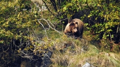
2026 (4) - Pages 81-105Habitat loss, alteration and fragmentation are among the main drivers of biodiversity decline worldwide. Carnivore species are particularly vulnerable to the risk of local extinction in fragmented landscapes due to their relatively wide ranges, low numbers and direct persecution by humans. In such fragmented landscapes, the viability of populations depends in particular on the effective dispersal of individuals across the landscape within their remaining distribution range, which generates gene flow, and on the functional connectivity of the landscape. The Pyrenean Brown Bear Ursus arctos Linnaeus, 1758 population is considered as one of the most threatened population of Brown Bear in Europe, due to its low abundance, high inbreeding and low population effective size, isolation from other European populations and fragmentation into two main historical nuclei. Landscape connectivity is thus a key issue for the long-term demo-genetic viability of this critically endangered population, by promoting genetic mixing. The aim of this study was to generate transboundary functional landscape connectivity maps characterising the ease of brown bear movement across Pyrenean landscapes and to identify natural and anthropogenic barriers and filters as well as corridors of movements. For that, we first created a resistance map following a habitat suitability approach (MaxEnt tool) and then used this resistance map to infer connectivity comparing two modelling approaches (the Least Cost Corridor implemented in the Linkage Pathways tool from the ArcGIS toolbox Linkage Mapper and the circuit theory implemented in the Omniscape.jl software). The results show that roads, agricultural areas and urban zones display a high resistant to movements. Bears prefer intermediate altitudes and the identified corridors thus avoid the highest Pyrenean massifs. Even though some differences occur between Linkage Pathways and Omniscape connectivity maps, some corridors are common to both modelling approaches. Those areas may be interesting targets for prioritizing areas for land-management plans (e.g., creating road overpasses and underpasses, designing protected reserves, planting trees), aiming at preserving or improving favourable habitats and landscape connectivity, as well as mitigating habitat fragmentation and collision risks with vehicles for brown bears in the Pyrenees. This should ultimately favour the long-term demo-genetic viability of the critically-endangered brown bear population in coexistence with human activities and help more broadly the conservation of Pyrenean biodiversity as brown bear is considered as an important umbrella, flagship and keystone species.
Landscape connectivity, Pyrenees, habitat fragmentation, wildlife corridors